NOTES:
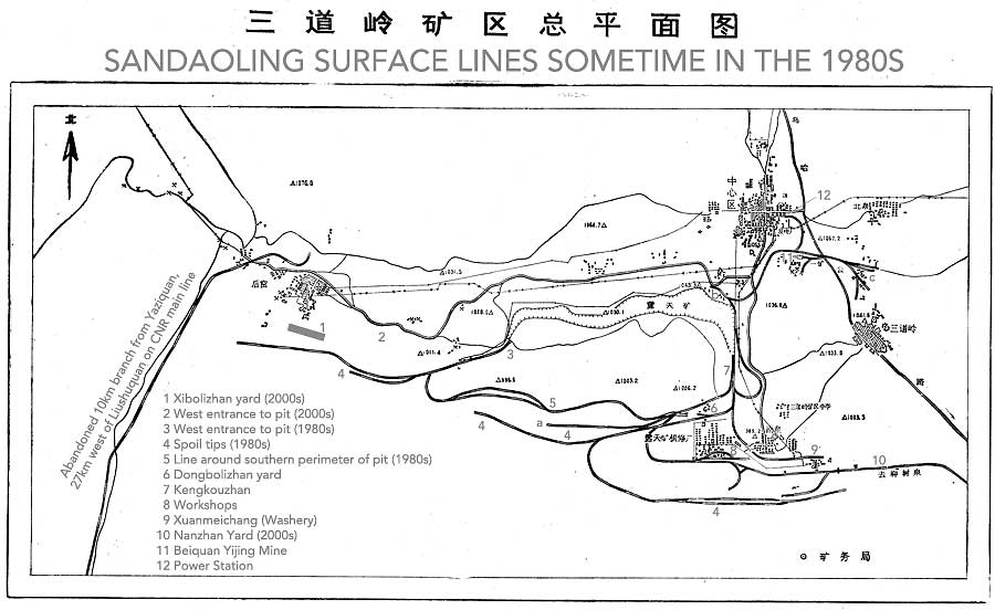
A larger version of this map can be viewed or downloaded here (3723x2009px, 458kB).This map only shows surface lines. The extent of the opencast pit is marked but not the lines within it.
Observations
The west end of the pit was extended westwards by around 2km between the time of this map and 2004, the date of the earliest available Google satellite images. Xibolizhan Yard wasn’t built at the time of the map and the line shown heading west out of the pit appears to follow the line of the spoil tips south of Xibolizhan. The connecting line along the southern perimeter of the opencast had been rebuilt further to the south by 2004, following the line marked ‘a’ on the map, and continuing west to Xibolizhan rather than dropping into the pit. It was relocated even further south between 2004 and 2010 and then rebuilt again as part of the connection to Shadunzi Mine in 2014.The eastern end of the opencast operation has changed far less in the same time. Dongbolizhan, the ‘washery’ at Xuanmeichang, the workshops and the nearby wye are all recognisable. The line passes the location of Nanzhan but there is no sign of any facilities there or of the line to Beiquan Erjing (Mine 2).
Beiquan Yijing (Mine 1) is shown connected to the east end of the opencast system at Kengkouzhan via a balloon and a reversal, the latter shown as ‘b’ on the map. This is roughly where the coal processing plant near Dongkengkou is now located, although this was still open ground in 2004. No sign of the reversal is visible on the Google images but the route of a direct line bypassing the reversal can be seen, as can the balloon. There is no line on the map from Yijing to Erjing, which presumably hadn’t been built at the time, but the power station north of Yijing is shown as being rail connected. The remains of the facility to the east of Yijing, shown as ‘c’ on the map, are visible on the Google images although its function is unclear.
The road layout also appears to have changed significantly.
There is a second map but it isn't as obvious what it shows, possibly the CNR main line and the long abandoned branch from Yaziquan to an industrial location west of Xibolizhan. Once again, a larger version can be viewed or downloaded here (3273x2314px, 554kB).
